 Slovenski INSPIRE metapodatkovni sistem
Keyword
Coordinate reference systems
2 record(s)
Type of resources
Categories
INSPIRE themes
Keywords
Contact for the resource
Representation types
Resolution
-
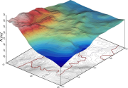
The database contains data about SLOvenian Absolute Model of Geoid from the year 2000 (SLOAMG2000). It is an astro-gravimetrical model, determined by a combined method. It is calculated by the least squares collocation method, using the "remove-restore" techniques. It refers to the GRS80 ellipsoid. The global geopotencial model EGM96 is used for the calculation. It is given in the form of a grid. The geoid model is used for the transformation of the ellipsoid heights (GNSS technology) into the normal-orthometric heights (above sea level) and vice versa. Heights above the sea level refers to the Slovenian height system SVS2000 with Trieste datum. The ondulation of geoid in Slovenia range from 44,140 to 48,724 m, with an average value of 46,453 m. Note: values are given only within the boundaries of Slovenia.
-
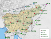
National Coordinate System Database contains data on national geodetic points, national network of permanent stations for positioning with the technology of global navigation satellite systems (hereinafter referred as: national network for global positioning) and the geographic coordinate network.